 Repeatability
of Marked Way Points Repeatability
of Marked Way Points
Repeatability
of Marked Way Points Repeatability
of Marked Way Points To acquire data on the repeatability of GPS readings I fitted my ETREX H GPS to my measuring bike and rode from the East end nail of my Long Tow calibration course to the West end nail. At each end I stopped and pressed the button on the ETREX to mark a way point and store the coordinates of the end nail as GB grid ref to 1m.
I recorded 18 pairs of points on 8 different days. I usually did two or more rides each day. Each ride of 700 m takes a little over 2 minutes, and consecutive rides on the same day were separated by typically 3 to 20 minutes.
My data were recorded with the GPS set in the WAAS mode, and normally in this mode it receives correction data from an EGNOS satellite (no 33 in the display) and indicates a differential error of either 3m or 4m.
In addition there was one pair of data points taken by Phil Holland with his higher spec ETREX shown with a square. All these these 38 points have been averaged to provide mean positions of the two ends (shown as yellow triangle in the plots for the East end, and as the red diamond in the plot for the west end).

In these 19 pairs of data points data there is one data point (E48283 N96798) taken at the West end of Long Tow which differs considerably from the other observations. This point was consistent with the series of track points recorded by the GPS as I approached the end nail, and then as I continued my ride in the same direction after recording way point at the nail. On this occasion The GPS track showed a considerable displacement from the normal location of recorded tracks. This showed that on this occasion the GPS had a substantial displacement (>10 m)that lasted for a substantial fraction of a minute.
Clearly more data is needed to confirm the frequency of occurrence of such larger errors. Even if this the data point (E48283 N96798) is excluded from consideration, there still appears to be rather more scatter at the West end of Long Tow than at the East end. There is no obvious reason for this since both locations are on open roads with a good view of the sky and very little in the way of nearby obstructions.
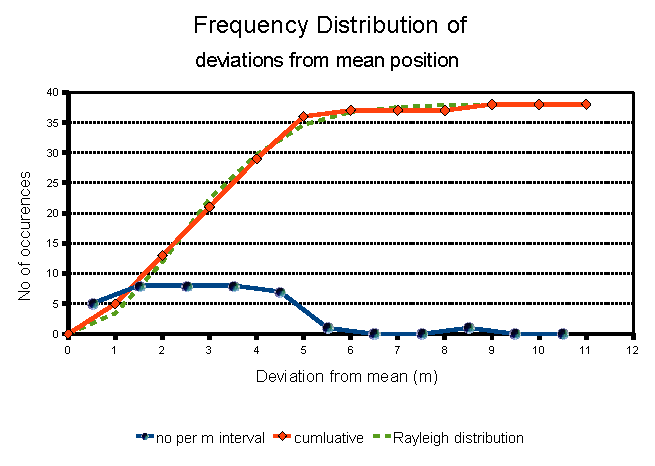 The
frequency of different magnitudes of deviation from these means have
also been plotted. The dark line shows the number of occurrences of
deviations from the mean in each 1 m interval. The red line shows the
same data as a cumulative plot. The dashed line shows a Rayleigh
distribution with
a parameter of 3.3 m closely fits the cumulative plot. For a Rayleigh
distribution with a parameter of 3.3 m, 50% of the points lie with
a circle of 2.7 m and 95% lie with in a circle of 6 m radius.
The
frequency of different magnitudes of deviation from these means have
also been plotted. The dark line shows the number of occurrences of
deviations from the mean in each 1 m interval. The red line shows the
same data as a cumulative plot. The dashed line shows a Rayleigh
distribution with
a parameter of 3.3 m closely fits the cumulative plot. For a Rayleigh
distribution with a parameter of 3.3 m, 50% of the points lie with
a circle of 2.7 m and 95% lie with in a circle of 6 m radius.
These values are broadly consistent with performance reported on the web by GPS users.
Without any averaging, Mike's ETREX H could be used to record and then refind reference points normally (ie 95% of the time) to better than about 8 m. Occasional errors might be greater. At this level of performance the Etrex H is not accurate enough the reliably record the exact start or finish of a race, which still needs to be measured by means of a Jones counter and a calibrated bicycle wheel, and referenced with an offset from a nearby piece of fixed street furniture. However a GPS can be very useful in recording the general location of the reference points and for example it could fairly reliably distinguish between trees of similar appearance separated by more than 20 m along a road side.
However a measurer should be aware that not every race director or indeed other measurers may have suitable equipment to be able to refind the references or indeed be able to operate it, as I discovered when I used grid refs to record the reference furniture locations for the mile splits for a recent country half marathon. When the organiser went out with a borrowed GPS to paint the mile marks, he could not master use of his GPS to locate the points, and he had to rely on the fact that I had provided a sufficiently comprehensive description of the location references (trees, gates, openings in hedges etc). That said, my record of the locations will certainly be useful aid to me if I have ever to go back and refind a lost reference. For example if a tree is cut down, I might be able to locate the correct stump, with the aid of my GPS. Occasionally I end up with paint marks on the road and no close by reference for a mile split. Here again, a GPS reference would usually be good enough to get me within a few metres so I could search for faint paint remnants.
Even for this limited use I think recording GPS way points at reference points will now be a regular part of my measuring procedure. There are however, other possible applications in course measuring which will be considered in other articles.
Mike Sandford - 31 March 2009